Why Aerial Images Make Some Listings Easier to Understand
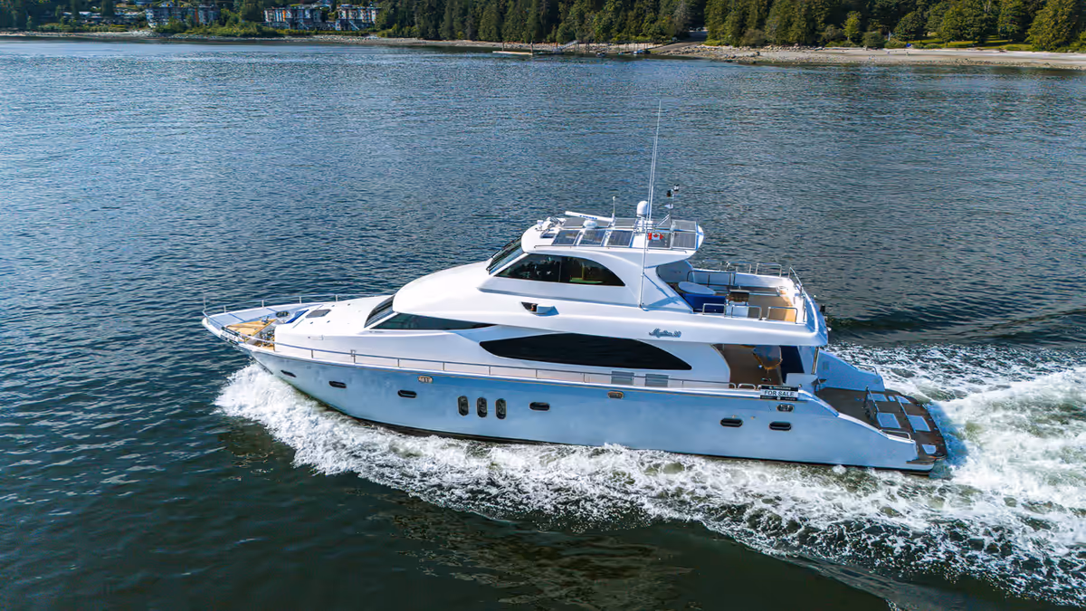
Drone photography gives real estate listings a perspective that ground-level media cannot always provide. A standard exterior photo can show the front of a home. Interior photography can show rooms, finishes, and layout. But aerial photography can show how the property sits within its surroundings.
For Vancouver realtors, this matters because many listings are not defined by the home alone. They are shaped by views, lot size, street position, privacy, nearby parks, waterfront access, skyline context, outdoor space, and neighbourhood feel.
Aerial production helps buyers understand those factors faster.
Drone photography is not necessary for every listing. Some properties are better served by strong interior photography, exterior images, floor plans, and video. But when location, scale, exterior context, or views affect buyer perception, drone photography can make the listing clearer and more visually memorable.
The key is to use aerial images with purpose. A drone should not be used only because the shot looks dramatic. It should be used because the elevated perspective helps buyers understand something important about the property.
Why Use Drone Photography in Real Estate?
Drone photography is useful because it expands the buyer’s view of the listing. Instead of only showing rooms and close exterior angles, drone images can show the full property environment.
This is valuable in real estate because buyers often want answers to practical questions:
- How large does the lot feel?
- How is the home positioned on the property?
- What surrounds the listing?
- How private is the outdoor space?
- What does the view actually look like?
- How close is the property to parks, trails, water, or urban amenities?
- Does the location support the lifestyle described in the listing?
Aerial photography helps answer these questions visually.
For Vancouver properties, this can be especially useful because location and setting often carry significant marketing weight. A North Vancouver home may benefit from showing mountain proximity. A West Vancouver listing may need to communicate views and privacy. A downtown condo may need aerial context around skyline, waterfront, or neighbourhood access. A larger detached home may need aerial images to show yard depth, landscaping, or lot orientation.
Drone photography can also support the agent’s brand. A listing with thoughtful aerial media signals that the property is being marketed with care and that the agent understands modern visual presentation.
A Better Way to Think About Drone Shots
The most effective drone photography is not a random collection of elevated images. It is a planned sequence that supports the listing story.
Before the drone is used, the realtor and production team should identify the reason for the aerial perspective.
The reason may be:
- To show lot size
- To show views
- To show proximity to amenities
- To show outdoor living areas
- To show architecture
- To show privacy
- To show waterfront or park access
- To create a stronger hero image
- To support social media content
- To make the listing feel more complete
This planning prevents aerial photos from becoming filler.
A drone image should have a job. If it does not clarify the property, support the story, or improve the marketing assets, it may not belong in the final gallery.
Showing the Property and Its Surroundings
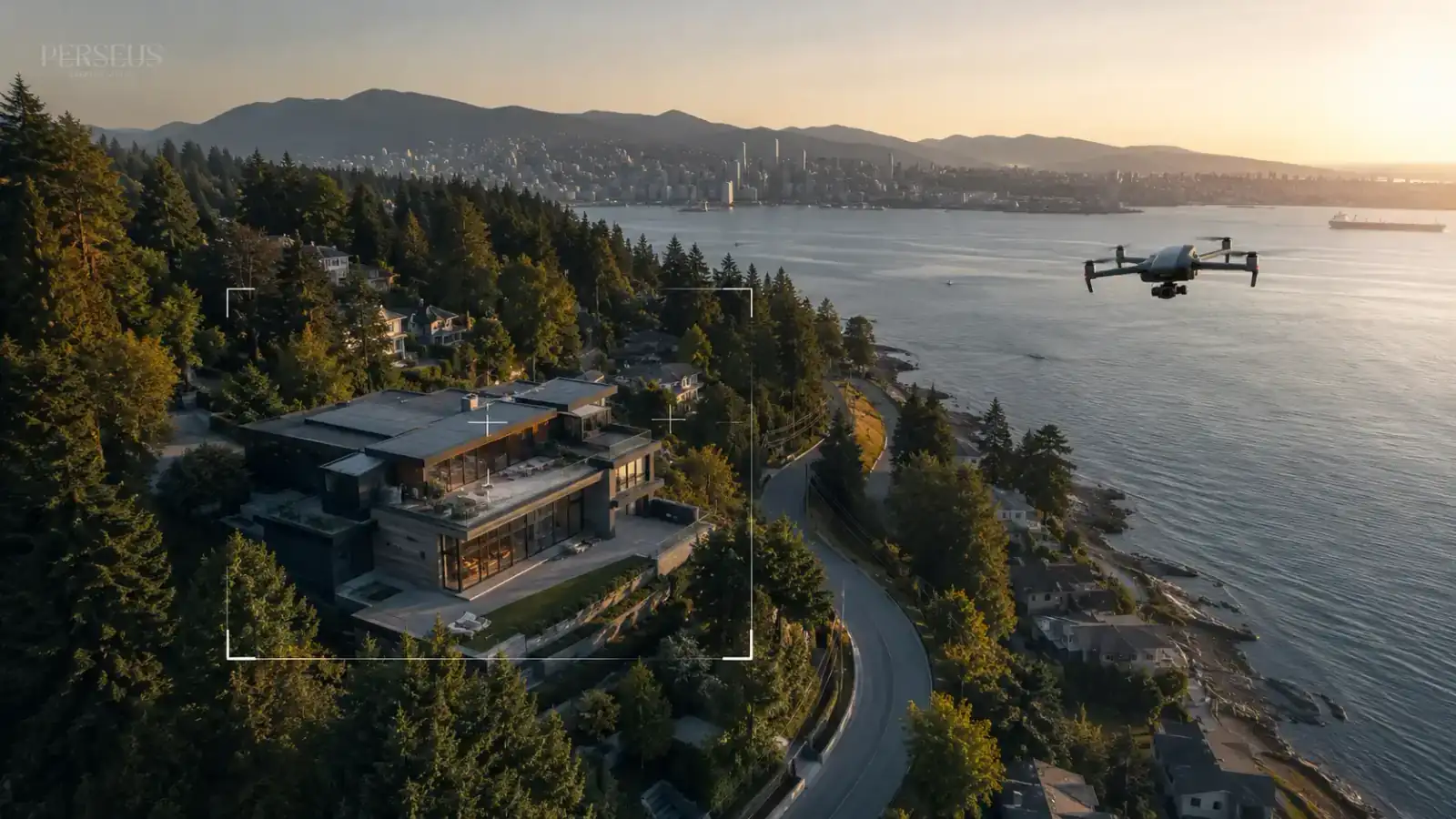
One of the strongest uses of drone photography is showing context. Buyers are not only evaluating the interior. They are evaluating where the home sits and how the surrounding area affects daily life.
Aerial photography can show the relationship between the property and:
- Streets
- Neighbouring homes
- Parks
- Trails
- Waterfront areas
- Commercial districts
- Schools
- Transit corridors
- Skyline views
- Mountain views
- Outdoor amenities
This does not mean every nearby feature should be photographed. The goal is to highlight what is relevant to the listing.
For example, if a property’s value is tied to quiet residential surroundings, aerial photography can show the street, tree coverage, and spacing around the home. If the value is tied to convenience, aerial images may show proximity to major neighbourhood features. If the property has a strong view, aerial photography can show the direction and openness of that view.
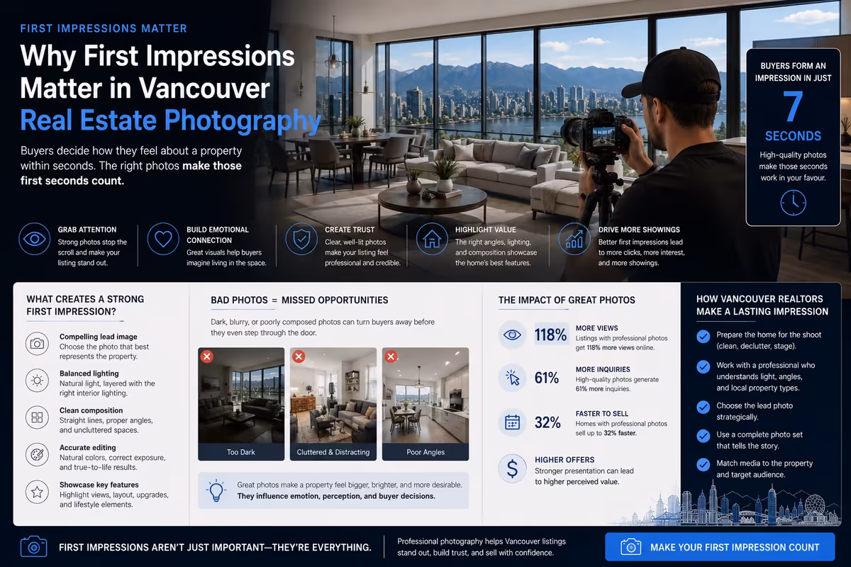
The best aerial images make the property easier to understand before the buyer reads a long description.
Why Drone Photography Helps Listings Feel Premium
Drone photography can make a listing feel more complete and professionally marketed. This is not because aerial images are automatically better than ground-level images. It is because aerial production can add scale, polish, and context when used properly.
A listing feels more premium when the media package looks intentional.
That means the photography has a logical flow. The exterior is presented clearly. The strongest features are captured from the right angles. The aerial images add meaningful context. The gallery does not feel rushed or random.
Drone photography can support a premium feel by creating:
- Stronger opening images
- More complete exterior coverage
- Better context around views and location
- More polished social media visuals
- Stronger website and campaign assets
- A more professional listing presentation for sellers
For Vancouver realtors, this matters because every listing is also a public example of the agent’s marketing standard. Sellers notice how listings are presented. Future clients can see whether the agent invests in strong visual assets.
Drone photography is not just for the current listing. It can also support the agent’s long-term brand perception.
Where Drone Photography Adds the Most Value
Drone photography is most useful when the aerial perspective reveals information that standard photography cannot easily show.
It often adds value for:
- Larger lots
- View properties
- Waterfront or near-waterfront homes
- Luxury listings
- Homes with outdoor living areas
- Properties near parks or trails
- Architecturally distinct homes
- Development properties
- Rural or semi-rural properties
- Homes with strong landscaping
- Properties where privacy is part of the value
It can also help with certain condo and townhouse listings when the building location, view, or surrounding amenities are part of the selling point.
The important question is not “Can we use a drone?” The better question is “Will aerial photography help buyers understand why this listing matters?”
If the answer is yes, drone photography belongs in the media package.
What to Capture With a Drone
Drone photography should be planned around the property’s strongest features. The exact shot list will depend on the listing, but several categories are commonly useful.
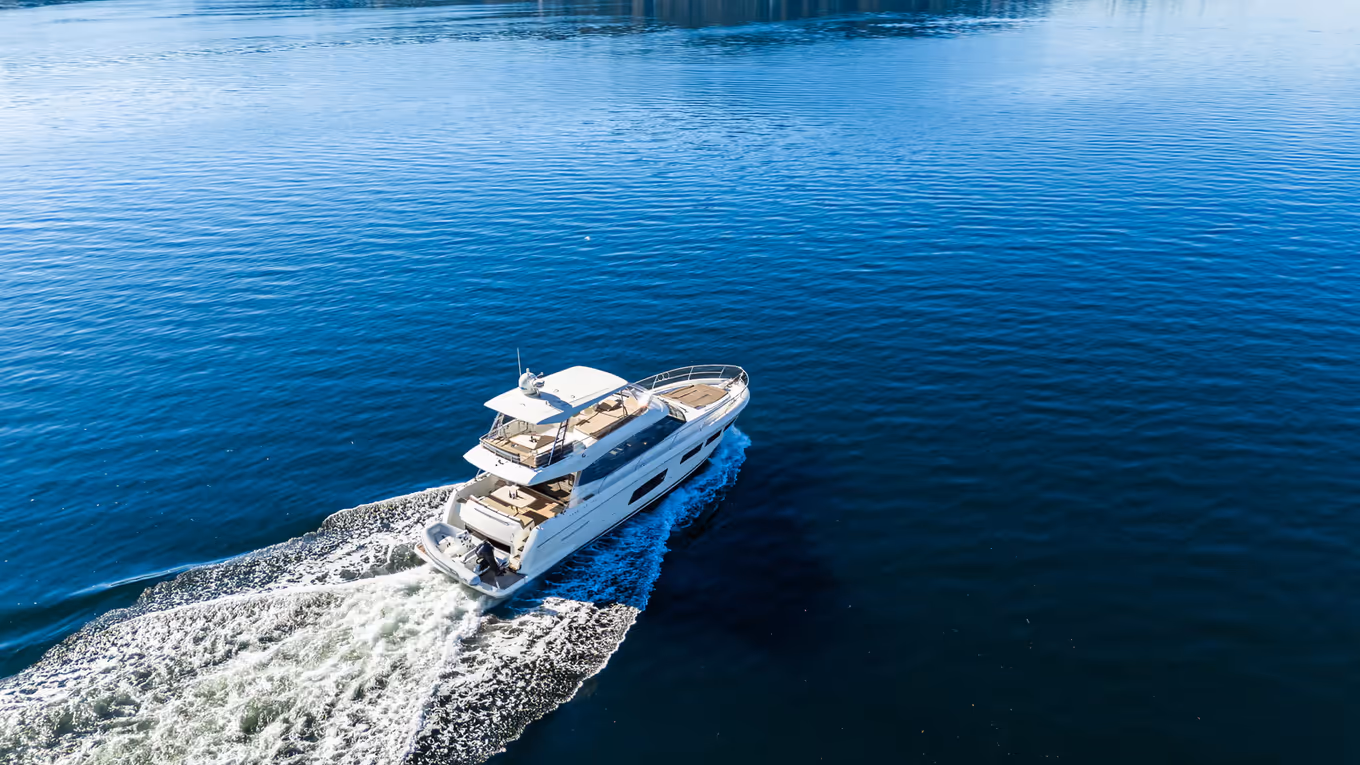
Establishing Images
An establishing image shows the property in context. It may include the home, the lot, the street, and surrounding neighbourhood features. This type of image works well near the beginning of a gallery or as a social media asset.
The purpose is orientation. It helps buyers understand where the property sits.
Elevated Exterior Angles
Elevated exterior angles can show the front elevation, landscaping, driveway, entry, roofline, and exterior design more clearly than ground-level images.
These shots are useful when curb appeal, architecture, or exterior condition matters to the listing story.
Top-Down Property Context
Top-down images can help show lot shape, outdoor areas, roof layout, yard size, and the relationship between different property zones.
They should be used carefully. A top-down image can be useful for scale, but it is not always the most emotionally engaging shot. It works best when it explains something important.
Outdoor Living Areas
Decks, patios, pools, gardens, lawns, rooftop spaces, and balconies can become more understandable from above. Drone photography can show how these spaces connect to the home and how usable they feel.
This is especially useful when outdoor space is a major selling feature.
View and Location Images
If the property has mountain, ocean, skyline, park, or neighbourhood views, drone photography can help show the view in context.
The goal is not just to capture a scenic image. The goal is to show how that view relates to the property.
Neighbourhood Context
Neighbourhood images can be helpful when location is part of the property value. These shots may show nearby parks, trails, waterfront access, walkable areas, or urban convenience.
They should be selective. Too many neighbourhood images can distract from the property. The best ones support the buyer’s understanding of location.
Combining Drone Photography With Short Video Clips
Even when the main deliverable is photography, it can be smart to capture short drone video clips during the same production window.
Aerial stills are useful for MLS, websites, brochures, and listing galleries. Short video clips can support social media, open house promotion, YouTube Shorts, Instagram Reels, TikTok, email marketing, and property teasers.
This creates more value from one shoot.
A listing may use aerial photography for the formal gallery, then use short drone clips to create movement and attention across social platforms. This is especially useful for realtors who want to keep a listing visible beyond launch day.
See Aerial Perspective in Motion
Drone photography gives buyers still-frame context. Drone videography adds movement, pacing, and reveal. When the two are planned together, the listing can feel more complete across both MLS and social platforms.
For real estate marketing, aerial content should always support the property’s strongest story. The best drone visuals show scale, setting, and context without distracting from the home itself.
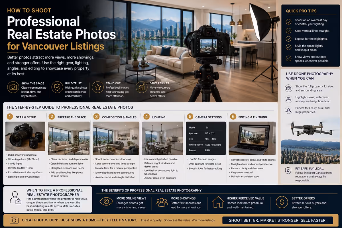
Flying Smart: Safety, Compliance, and Planning
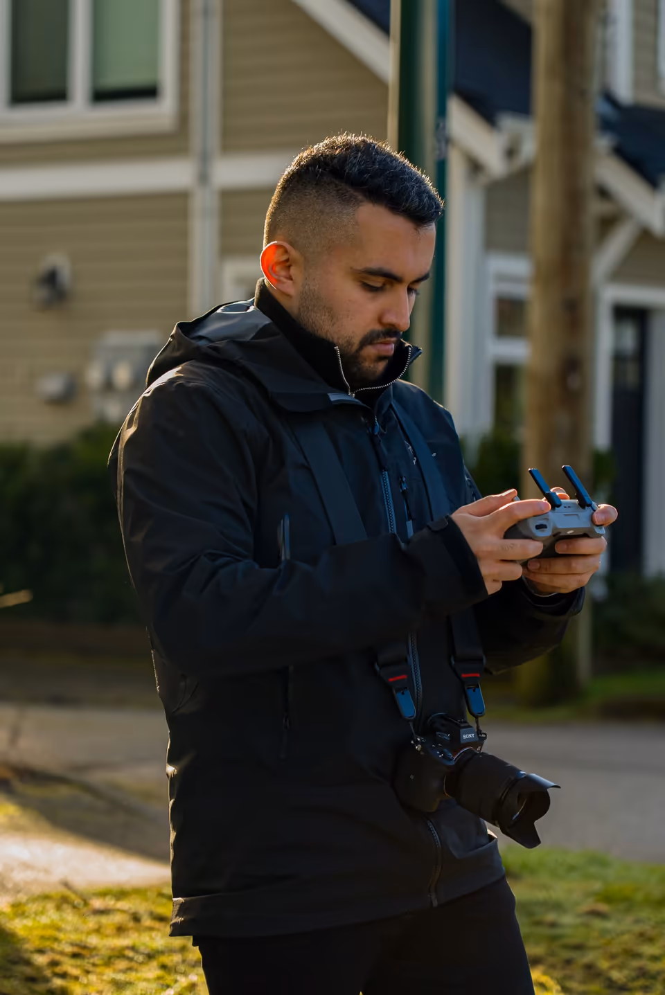
Drone photography for real estate should be handled professionally. Aerial production involves more than creative shot selection. It also requires safe operation, planning, airspace awareness, and compliance with current rules.
In Canada, Transport Canada provides official guidance on drone safety, registration, pilot certification, operation categories, and where drones can fly. Because rules can change and depend on the operation, realtors should work with qualified operators and confirm requirements before aerial production is planned.
For a real estate shoot, the production team should consider:
- Whether drone operation is appropriate for the location
- Current airspace conditions
- Property access
- Nearby people, roads, buildings, airports, or heliports
- Weather and visibility
- Privacy considerations
- Building, strata, or property permissions where relevant
- Whether the planned shots can be captured safely
- Backup options if conditions are not suitable
This matters in Vancouver because many properties are located near dense neighbourhoods, controlled airspace, waterfront areas, high-rises, traffic, or shared residential buildings.
A strong drone plan protects the seller, the agent, the production team, and the people around the property.
Permissions for Condos, Strata, and Shared Spaces
Drone photography can be more complex for condos, townhomes, strata properties, and shared buildings.
Even when drone operation is legally possible, the production team may still need to consider property access, building rules, privacy, shared amenities, and practical flight conditions. A realtor should not assume that aerial production around a building is automatically straightforward.
Before scheduling drone photography for a shared property, confirm:
- Building or strata restrictions
- Access to common areas
- Whether exterior amenities can be photographed
- Privacy concerns around neighbouring units
- Safe takeoff and landing areas
- Whether building management needs advance notice
- Whether alternative ground-level or elevated shots may be more appropriate
This planning helps avoid delays and reduces the chance of problems on shoot day.
For some condo listings, drone photography may not be necessary. If the unit’s value is mainly interior layout, finishes, or amenities, standard photography and video may be more useful. If the value is tied to views, location, or building context, aerial media may make more sense.
Shooting Conditions That Improve Drone Photography
Aerial images are heavily influenced by weather, light, visibility, and timing.
Soft light usually creates cleaner exterior images. Harsh midday sun can create strong shadows and make some angles less flattering. Poor weather can reduce visibility and weaken views. Wind can make aerial production less practical.
For Vancouver properties, weather planning matters. Cloud cover, rain, haze, and seasonal lighting can affect the final images.
A strong production plan should consider:
- Time of day
- Direction of light
- View visibility
- Wind conditions
- Rain forecast
- Exterior readiness
- Traffic and neighbourhood activity
- Whether twilight or golden-hour visuals are worth planning
The goal is not always to wait for perfect conditions. The goal is to choose conditions that support the property’s strongest features.
A view property may need clearer visibility. A home with strong landscaping may need soft exterior light. A listing with architectural details may benefit from controlled shadows and clean angles.
Technical Choices That Matter More Than Gear Names
It is tempting to focus on specific drone models, but equipment should not be the starting point. For real estate marketing, the more important question is whether the final media supports the listing.
Instead of choosing drone gear based on popularity, focus on production requirements:
- Image quality
- Reliable stabilization
- Ability to capture sharp stills
- Safe operation features
- Battery planning
- Appropriate lens and field of view
- Editing flexibility
- Compliance with the operation type
- Ability to produce both stills and short clips
- Suitability for the location and property
A drone is only one part of the production process. Planning, composition, timing, safety, and editing have a major effect on the final result.
For Vancouver realtors, this is the practical takeaway: do not buy drone visuals as equipment. Buy them as a marketing deliverable. The output should help the listing look clearer, more complete, and more competitive online.
Editing Drone Photos for Real Estate Marketing
Editing matters because aerial photos need to match the rest of the listing package. If the drone images look overprocessed, too dark, too saturated, or visually different from the interior gallery, the listing can feel inconsistent.
Good editing should improve clarity without making the property feel unrealistic.
Drone photo editing usually focuses on:
- Exposure balance
- Colour consistency
- Straight horizons
- Clean composition
- Natural contrast
- View clarity
- Image sharpness
- Cropping for web, MLS, and social media
Consistency is important. Aerial images should feel like part of the same campaign as the interior photography, exterior photography, and video.
This is where professional post-production helps. It keeps the media package polished and usable across multiple platforms.
How Drone Photography Supports Social Media
Drone photography is useful beyond MLS. Aerial images can create strong social media posts, carousel openers, story content, and campaign visuals.
For realtors, this matters because social media is often where listings earn repeated attention.
Aerial images can be used for:
- Listing launch posts
- Open house reminders
- Neighbourhood highlight posts
- Instagram carousel covers
- Facebook listing posts
- Email banners
- Website hero images
- Paid ad creative
- Seller presentation examples
When combined with short drone video clips, the listing can have both strong still images and motion-based content.
This gives agents more flexibility. Instead of posting the same interior photo repeatedly, they can use aerial visuals to vary the campaign and keep the property presentation more engaging.
Common Drone Photography Mistakes to Avoid
Drone photography can improve a listing, but only when it is executed with restraint and purpose.
Common mistakes include:
- Using drone images when they do not add meaningful context
- Capturing too many generic overhead shots
- Showing surrounding areas that weaken the property story
- Ignoring lighting and weather
- Using distorted or poorly composed images
- Making the property difficult to identify in the frame
- Overediting skies, views, or colours
- Failing to match drone images with the rest of the photo gallery
- Ignoring permissions or safety planning
- Treating aerial production as a last-minute add-on
The best aerial media feels intentional. It shows what buyers need to understand and avoids unnecessary visual noise.
A clean, useful drone image is better than a dramatic image that does not support the listing.
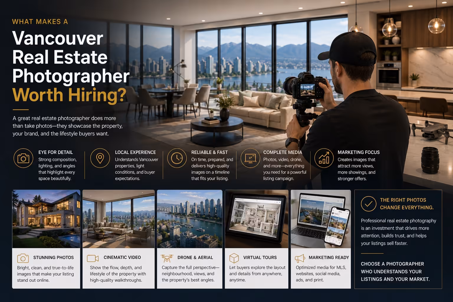
How Perseus Creative Studio Helps Vancouver Realtors With Drone Photography
Perseus Creative Studio helps Vancouver real estate agents and brokerages create listing media that supports modern property marketing.
Our aerial production process starts with strategy. We look at whether drone photography will help communicate the listing’s scale, views, location, outdoor areas, privacy, or neighbourhood context. If aerial media adds value, we plan it into the broader campaign.
That campaign may include real estate photography, videography, aerial production, editing, and short-form social content. The goal is to create assets that work across MLS, websites, social media, email campaigns, open house promotion, and seller presentations.
A downtown condo, North Vancouver view property, West Vancouver luxury listing, and East Vancouver family home all need different visual strategies. Drone photography should reflect the property’s actual strengths.
Explore our real estate photography, videography, and aerial production services, or contact Perseus Creative Studio to plan aerial media for your next Vancouver listing.
Key Takeaway
Drone photography helps Vancouver real estate listings show context that standard media cannot always capture: lot size, exterior layout, outdoor space, views, privacy, and neighbourhood setting.
The best drone images are not just high-angle visuals. They are strategic marketing assets. They help buyers understand the property faster and give agents stronger content for MLS, websites, social media, email, and seller presentations.
For Vancouver realtors, drone photography is most effective when it is planned safely, used selectively, and integrated into a complete listing media package.