Why Aerial Perspective Changes the Way Buyers See a Property
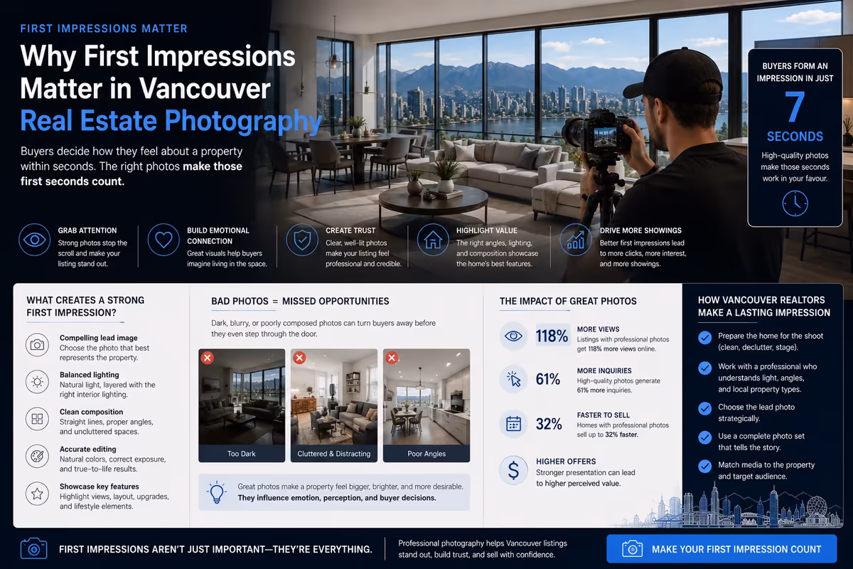
A real estate listing is not only about the rooms inside a home. Buyers also care about land, views, outdoor space, street position, nearby amenities, privacy, access, and the overall setting. Ground-level photography can show many of these details, but it cannot always explain the full context.
That is where aerial real estate photography becomes valuable.
For Vancouver realtors and brokerages, aerial photography can help show a listing from a perspective buyers cannot get from standard interior photos. It can reveal the property’s relationship to the surrounding neighbourhood, the scale of the lot, the strength of the view, the shape of the exterior space, and the location advantages that may be difficult to communicate through words alone.
Aerial photography does not belong in every listing package automatically. It should be used when it adds clarity, context, or value to the property presentation. When used strategically, aerial production can make a listing easier to understand, easier to market, and more visually memorable.
The Power of Perspective
Perspective matters in real estate marketing because buyers often make early decisions with incomplete information. A listing may include strong interior photos, a polished description, and a floor plan, but buyers may still wonder how the property sits on the lot or what surrounds it.
Aerial photography helps answer those questions.
From above, buyers can see the relationship between the home, yard, street, neighbouring properties, views, outdoor features, and nearby landmarks. This is especially useful in Vancouver, where location and surroundings can heavily influence buyer interest.
Aerial perspective can show:
- How the property sits on the lot
- The size and usability of outdoor areas
- The relationship between the home and the street
- Mountain, city, water, or neighbourhood views
- Proximity to parks, waterfronts, trails, schools, or commercial areas
- Architectural shape and exterior design
- Privacy, orientation, and surrounding density
Aerial photography gives the listing a larger visual frame. Instead of only showing what is inside the property, it helps buyers understand where the property belongs.
Why Aerial Photography Works for Real Estate Listings
Professional real estate photography usually starts with interior and exterior still images. Those images are essential because buyers need to see the rooms, finishes, layout, and condition of the home.
Aerial photography adds a different layer. It supports the larger story around the listing.
For example, a property may have a renovated interior, but its strongest value may also come from a large backyard, a quiet street, a corner lot, a view corridor, or proximity to natural surroundings. Standard photos can show parts of those features. Aerial images can show how they fit together.
This matters because buyers do not only buy square footage. They buy access, setting, convenience, lifestyle, privacy, and long-term usefulness.
Aerial photography helps communicate those elements with fewer assumptions. Instead of asking buyers to imagine the location, the listing can show it.
For Vancouver real estate agents, this is particularly useful when marketing properties where surroundings are part of the value proposition. A downtown condo with a skyline outlook, a North Shore home near trails, a West Vancouver view property, or a family home with a large lot can all benefit from aerial context.
Showcasing Big Properties
Large properties can be difficult to explain through ground-level photography alone. A standard exterior photo may show the front of the home, but it may not show the full lot, outdoor zones, driveway layout, garden space, detached structures, or relationship between different areas of the property.
Aerial photography helps make scale visible.
For larger homes, estates, development properties, or properties with meaningful outdoor space, aerial images can show:
- Total lot presence
- Yard depth and shape
- Driveway and parking areas
- Garden layout
- Pools, patios, decks, or outdoor entertaining areas
- Detached garages, laneway structures, or accessory buildings
- Tree coverage and privacy
- How the home is positioned on the property
This helps buyers understand the full property, not just the building.
Aerial photography is also useful when a property has multiple outdoor zones. A backyard may include a patio, lawn, garden, and secondary structure. Ground-level images can show each feature individually, but aerial photography can show how the full outdoor environment works together.
For buyers comparing larger properties online, this clarity can be important. It helps them decide whether the property is worth deeper consideration.
Showcasing Unique Locations
Location is one of the most important elements in real estate, but it can be difficult to show with standard listing photos. A property description can mention nearby parks, waterfront access, school proximity, mountain views, walkability, or quiet streets, but buyers often need visual context to understand why those details matter.
Aerial photography can make location value more visible.
For Vancouver listings, aerial production can help showcase:
- Ocean, mountain, skyline, or park views
- Waterfront proximity
- Nearby trails or green space
- Urban access and neighbourhood density
- Distance from major roads
- Quiet residential surroundings
- Building position within a condo or townhouse complex
- Relationship to nearby amenities
This is especially valuable when the location is one of the property’s strongest selling points.
A condo near the seawall, a home close to forest trails, or a property with a strong view corridor may not be fully represented by interior photos alone. Aerial images can help buyers understand the setting immediately.
The key is to use aerial photography with purpose. The best aerial images do not simply show that a drone was used. They show something buyers need to understand.
The Tech Advantage
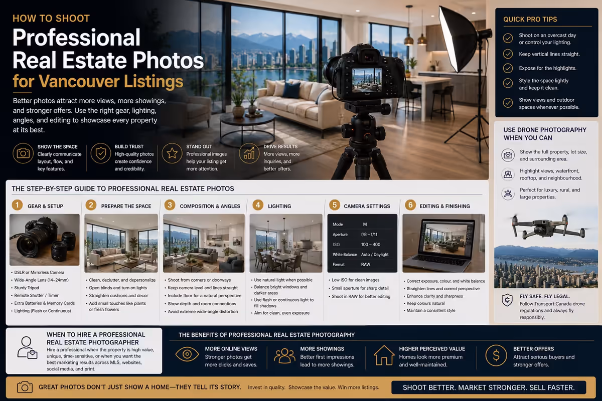
Aerial production gives realtors a technical advantage because it creates assets that standard photography cannot easily produce. Drone photography can capture elevated angles, overhead views, exterior context, and location relationships from a controlled visual perspective.
That said, technology alone is not enough. Aerial photography still needs composition, timing, editing, and strategy.
A good aerial image should have a clear purpose. It should highlight location, scale, architecture, view, lot position, or neighbourhood context. If an aerial image does not add information or emotional value, it may not need to be included.
Professional aerial production considers:
- Flight planning
- Weather and lighting conditions
- Safety and compliance
- Composition
- Neighbourhood context
- Image sequencing
- Editing consistency
- How the assets will be used across listing platforms
For Vancouver real estate marketing, this matters because aerial work is not only about capturing a dramatic image. It is about producing useful media that supports the listing campaign.
Aerial photography can also support other formats. The same production session may provide still images for MLS, website banners, social media posts, email campaigns, open house promotion, and listing presentations.
When Aerial Photography Is Worth Including
Aerial photography is most valuable when the property has features that benefit from elevated context. It may not be necessary for every condo or small listing, but it can be highly useful when the surroundings or exterior features influence buyer perception.
Aerial photography is worth considering when the property includes:
- A large or unusual lot
- Strong views
- Waterfront or near-waterfront proximity
- Significant outdoor space
- Architectural exterior features
- A premium location
- Development potential
- Rural or semi-rural surroundings
- Privacy from neighbouring homes
- A location near parks, trails, schools, or commercial areas
- A luxury positioning strategy
It can also be useful when the agent wants a stronger visual asset for social media. Aerial images often create a cleaner sense of place than ground-level photos, especially when the property’s location is part of the story.
The decision should be based on marketing value, not novelty.
When Aerial Photography May Not Add Much Value
Aerial photography is effective, but it is not always necessary. Some listings are better served by strong interior photography, exterior ground-level images, floor plans, or property video.
Aerial photography may add limited value when:
- The property has no meaningful exterior context
- Surrounding buildings block the useful view
- The location does not photograph well from above
- Weather or lighting weakens the result
- The listing needs speed over production depth
- The budget is better spent on interior photography
- Drone use is restricted or impractical in the area
This does not mean aerial production should be avoided. It means the media package should match the property.
A professional approach looks at the listing and asks what the buyer needs to understand. If aerial images answer an important question, they belong in the package. If they do not, another format may be more useful.
Aerial Photography and Standard Real Estate Photography Work Best Together
Aerial photography should not replace standard real estate photography. It should support it.
Interior and exterior photography are still essential because buyers need to see rooms, finishes, condition, lighting, and layout. Aerial photography adds a wider view that helps explain setting and scale.
A complete real estate photo package may include:
- Interior photography
- Exterior photography
- Detail shots
- Outdoor living images
- Aerial photography
- Twilight images where appropriate
- Social media crops
- Website-ready banner images
This combination gives the listing more flexibility across platforms. MLS may need a clean gallery. Social media may need a stronger hero image. A website may need a wide exterior banner. An email campaign may need a single high-impact visual.
Aerial production gives agents more options.
How Aerial Images Improve Listing Storytelling
Strong listing marketing is not just a collection of images. It is a story about why the property matters.
Aerial photography can strengthen that story by giving buyers context at the right moment.
For example, if the listing story is about privacy, aerial images can show tree coverage and spacing from neighbouring properties. If the story is about location, aerial images can show proximity to parks, water, or neighbourhood amenities. If the story is about scale, aerial images can show lot depth and outdoor areas.
This helps the listing feel more intentional.
Instead of saying “large lot” or “great location” and expecting buyers to accept it, the media can show the evidence visually. That does not remove the need for accurate descriptions, floor plans, or agent expertise. It supports them.
For Vancouver realtors, this can make the listing more persuasive without sounding overpromotional.
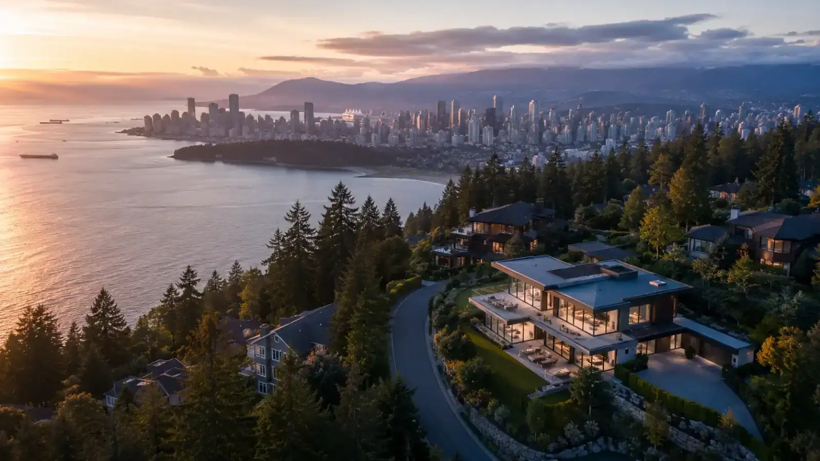
Aerial Photography for Luxury and View Properties
Luxury and view properties often benefit strongly from aerial photography because the exterior context is part of the perceived value.
A luxury property may need to communicate privacy, architecture, arrival experience, outdoor entertaining areas, scale, and surrounding landscape. A view property may need to show the direction, openness, and quality of the view. A waterfront or near-waterfront property may need to show the relationship between the home and the water.
Ground-level photography can show parts of this. Aerial photography can show the full context.
For premium listings, the expectation for media quality is also higher. Buyers and sellers often expect photography to feel polished, intentional, and aligned with the property’s position in the market.
Aerial production helps meet that expectation when it is executed properly.
Aerial Photography for Condos and Urban Properties
Aerial photography is not only for large detached homes. It can also support condo and urban property marketing when location is a key selling point.
For Vancouver condos, aerial images can help show:
- Building location
- Views and orientation
- Nearby waterfront or parks
- Urban convenience
- Neighbourhood density
- Transit or commercial proximity
- Relationship to surrounding towers
The key is selectivity. Aerial photography should not be used just to show a generic rooftop or city block. It should clarify a meaningful advantage.
For example, if a condo’s strongest appeal is its view, neighbourhood access, or proximity to the seawall, aerial images can help the listing communicate that quickly.
Safety, Compliance, and Professional Standards
Aerial production should be handled professionally. Drone operation involves safety, planning, and regulatory considerations. For Canadian operations, Transport Canada provides rules, guidance, registration information, and drone pilot licensing details for drone safety.
For real estate agents, this matters because aerial production is not only a creative decision. It is also a production responsibility.
A professional aerial production process should account for:
- Safe operation
- Appropriate permissions where needed
- Airspace considerations
- Weather and visibility
- Nearby people, buildings, and traffic
- Respect for privacy
- Practical shot planning
- Backup plans if conditions are poor
Agents do not need to manage every technical detail themselves, but they should work with production partners who understand that drone work requires more than simply arriving with equipment.
Professional standards protect the quality of the media and the integrity of the listing campaign.
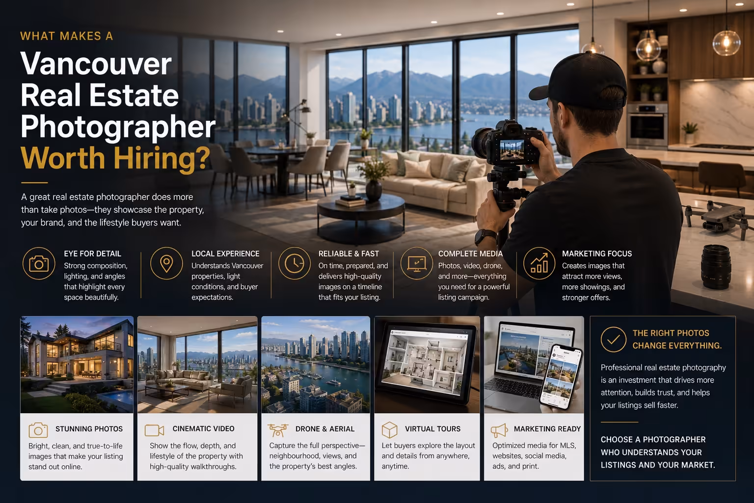
How Perseus Creative Studio Helps Vancouver Realtors with Aerial Production
Perseus Creative Studio helps Vancouver real estate agents and brokerages create professional listing media that supports modern property marketing.
For aerial photography and aerial production, our focus is not simply to capture elevated images. It is to identify when aerial perspective actually improves the listing story.
That may mean showcasing a large lot, a view corridor, a waterfront-adjacent location, a quiet residential setting, a luxury exterior, or a property’s relationship to nearby amenities. It may also mean deciding that a listing needs stronger interior photography first.
The right media package depends on the property and the campaign.
For Vancouver realtors, we help connect photography, aerial production, editing, and marketing strategy so listing assets are useful across MLS, websites, social media, email campaigns, paid advertising, and seller presentations.
Explore our real estate photography and aerial production services, or contact Perseus Creative Studio to plan media for your next Vancouver listing.
Key Takeaway
Aerial real estate photography helps Vancouver listings show what standard ground-level images cannot always capture: scale, setting, views, outdoor space, location, and neighbourhood context.
It is most effective when used strategically. Aerial production should support the property’s strongest selling points and help buyers understand why the listing is worth their attention.
For realtors and brokerages, aerial photography is not just a visual upgrade. It is a way to make the listing clearer, more complete, and more competitive online.